Wednesday, November 16, 2011

On Darwin's Dilemma

I did not enjoy this movie. It was made by a blatant Intelligent Design propaganda group. Most of the "experts" in the film are employed by The Discovery Institute, a group that specifically does science with the telos of proving the existence of an intelligent designer.

While the questions that they raise are pertinent, such as questions about the Cambrian explosion and the different phylum classes, the solutions and alternatives that they present are unscientific and ridiculous. The use of science to promote an absolutely unscientific ideology makes me sad.

I don't think showing the film was a good idea, and I think that it should have been discussed and clarified in class.

Ocmulgee National Monument

We went to the Ocmulgee National Monument for this lab.

It was pretty amazing, actually. We went to a new place that I had never been before--a creek on the back side of the park. I really enjoy the park, and even though a park ranger talked a lot and really only told us about a lot of conjecture and very little actual information, he was still nice, and he pointed out the Clovis spear or arrow head in the large room of the visitor's center.

Other than that, we really did things that I would normally do at t he park. We walked to the large Temple mound and stood on top of it. The swamp looked very nice.

The real learning of the lab took place at the creek. We were able to look at all the strata that make up the landscape. The creek was like a scar in the forest--it was very deep.

We also saw kaolin, a kind of clay that people in Georgia like to eat and chew on to settle their stomachs. But that is really, really weird.

Feedback (The Negative Kind)


A negative feedback loop is when a system overcompensates for a phenomenon by feeding back into itself and recreating a homeostatic environment.

Dr. Rood helped us create a chart based on the experiment that he did on himself in class. He ate a Snickers bar really quickly and then drank a soda and measured the reaction that his body had to the sugar. It was pretty amazing. The chart is at the top of this post!


Wednesday, October 5, 2011

ALL THAT SOIL!

So last Wednesday we had a lab that took us to a community garden in Macon, GA that is maintained through MaconRoots.org. It's a pretty cool thing, though I'm not sure if organic gardening means letting ants destroy a large portion of your crop. There has to be some kind of natural treatment for ants.

In any case, we did a lot of different things. We took soil samples and looked that different layers of dirt in the area, though we really only barely got down into the clay layer. We also dug up some dirt and felt it with our hands. Sometime around then, we sifted some dirt, though that was not super successful since it was pretty wet and rainy and whatnot that day.

I remember being cold.

Then we ate some different things from the garden and threw dirt at Dr. Rood and Alvin Huff couldn't figure out how a faucet works so I had to help him out with that.

Also, I found out about inceptisols, which are soils that are not very developed. It's like going back in time--soil time, if you will. This is a helpful link for learning about them.

And that was my lab experience.

Tuesday, September 27, 2011

Trees


Flowering Dogwood -- Cornus florid
American Holly -- Ilex opac

Live Oak -- Quercus virginian


Southern Magnolia -- Magnolia grandiflora


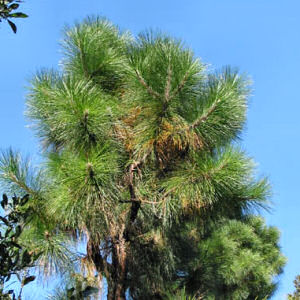
Long-leaf Pine -- Pinus palustri

Sunday, September 25, 2011

Rivertime Extravaganza!

So we went to the river and did a lot of stuff. Well, I picked up trash, but other people did lots of interesting things with measurements and strings and flow and all that info.

This map that follows is a map of clam concentrations on the river. From this map, we learned that clams like more shallow water. The deeper water had fewer clams. We also learned that birds or other animals will dig up the clams on the sand banks/bars and eat them, which is why there were no living clams sometimes.


The second map is the river transec map. I was not part of the group that collected this data, so I made the map with four equally divided parts in order to give an estimation of the number of feet across the river. By comparing the map I have made with the graph that follows it, it becomes easy to see the shape of the river bottom.


Thursday, September 8, 2011

More Maps!

This is a map I made using Google Earth. It is of the Ocmulgee National Monument. I have a place marker, a colored area of the swamp lake, and a path showing how to get from the first mound to the temple mound.